New York City isn’t running out of space; its planning rules are systematically designed to trade public sunlight and parks for private vertical wealth.
- « Air rights » and « as-of-right » loopholes allow developers to bypass public review and build taller than the zoning code seemingly allows.
- So-called « public » spaces like corporate atriums (POPS) are often a legal fiction, trading immense zoning bonuses for minimal, unwelcoming amenities.
Recommendation: Understanding this « invisible architecture » of regulations is the first step for residents to effectively challenge a system that prioritizes financial assets over livable communities.
To the resident on the street, the feeling is undeniable: New York City is shrinking. Not in population, but in the breathable, livable space that makes a city a home. The sky vanishes, familiar sightlines are severed, and public parks—the city’s cherished « lungs »—are increasingly cast in the permanent twilight of new, impossibly slender skyscrapers. The common explanation points to simple economics and developer greed. While not untrue, this narrative misses the more profound and unsettling reality. The forest of supertalls piercing the Manhattan skyline is not an anomaly; it is the calculated result of the city’s own planning framework.
The central argument of this analysis is that New York’s urban form is shaped less by architects’ blueprints and more by an invisible architecture of legal loopholes, financial incentives, and tradable commodities. The city’s Zoning Resolution has become less a tool for ensuring public well-being and more a marketplace where public assets like sunlight and open space are bartered for private vertical gain. This isn’t merely about tall buildings; it’s about a systemic failure to value the horizontal plane where the vast majority of citizens live, work, and gather.
This article dissects the specific mechanisms that favor supertalls over parks. We will explore how developers legally purchase « air » to exceed height limits and how shadow studies are rendered toothless. We will uncover the flawed promise of privately owned public spaces and contrast New York’s laissez-faire approach with cities that actively protect their public realm. By understanding this system, we can begin to question the fundamental trade-offs being made on our behalf and reconsider what a truly « public » good looks like in the 21st-century city.
This guide breaks down the complex legal and financial frameworks that dictate our skyline. The following sections will walk you through the key levers of power, from obscure zoning rules to the starkly different approaches taken by other global cities.
Summary: The Systemic Trade-Off: Unpacking How NYC Exchanges Public Space for Private Towers
- The « Right to Light »: How Developers Dodge Shadow Studies
- The Hidden Indoor Parks: How to Use Corporate Atriums for Free
- How Community Boards Can (Sometimes) Stop a Skyscraper
- London vs. New York: Which City Protects Its Sightlines Better?
- The 2050 Waterfront: Planning for Rising Sea Levels
- How Developers Buy « Air » from Neighbors to Build Higher Than Allowed
- Selfie Bait vs. Public Art: What Makes a Structure Meaningful?
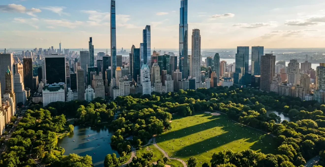
- Why New York’s Super-Tall Skyscrapers Are Casting Longer Shadows on Central Park?
The « Right to Light »: How Developers Dodge Shadow Studies
In theory, a city that values its public parks would rigorously scrutinize any new development that threatens to plunge them into darkness. In New York, however, the concept of a « right to light » is a legal fiction. The primary mechanism for building supertalls without extensive public debate is the principle of « as-of-right » development. If a project complies with the base zoning code, it can proceed without the need for special permits or a comprehensive public review process—the very forums where shadow impacts would be most fiercely debated.
This creates a critical loophole. The existing zoning and environmental review regulations were written for a different era of construction and, according to shadow studies produced by the Municipal Art Society, do not sufficiently protect Central Park from the impacts of modern supertalls. Developers exploit this outdated framework to build to unprecedented heights. This circumvention of public oversight is not an accident; it’s a feature of the system.
As advocacy groups have pointed out, the process is fundamentally skewed in favor of development. As Valerie Brown, a spokesperson for the Stand Against the Shadows campaign, noted, « Developers are under no obligation to seek city or community approval or input, nor carry out any environmental studies, to build to these unprecedented heights. » This means that long-shadow studies, when they are conducted, often come too late in the process, serving more as a record of damage done than a preventative tool. The system is not designed to ask *if* a shadow should be cast, but merely to document how long it will be once the tower is approved.
The Hidden Indoor Parks: How to Use Corporate Atriums for Free
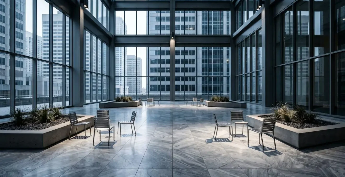
One of the most significant trade-offs in New York’s planning history is the creation of Privately Owned Public Spaces (POPS). In exchange for providing a « public » amenity—typically a plaza, arcade, or indoor atrium—developers are granted bonus floor area, allowing them to build significantly larger and more profitable buildings than the zoning code would otherwise permit. The scale of this exchange is immense; research has resulted in a network of over 590 privately owned public spaces, creating a supposed 80 acres of public land in return for millions of square feet of extra development rights.
This presents the ultimate façade of publicness. While the public receives a space in name, the developer receives a permanent, highly valuable financial asset. The problem lies in the quality and genuine public nature of these spaces. Many are designed with hostile architecture—uncomfortable seating, a lack of amenities, and imposing security—that subtly discourages public use and lingering.
This is not a recent phenomenon. A comprehensive study of POPS found that the program’s promise often falls short of reality. The findings were stark:
Case Study: The Flawed Promise of POPS
A landmark study by Harvard professor Jerold S. Kayden between 1998-2000 assessed the quality of New York’s POPS. It found that while the quantity of space created was impressive, the quality was often lacking. The study revealed that a staggering 41% were of marginal quality. Developers, particularly in the 1960s and 70s, would provide minimal paving, declare it a « plaza, » and collect their lucrative floor area bonuses in full compliance with the law. The study also documented how many owners illegally privatized their spaces through hostile design and rules that were never enforced by the city.
The result is a city dotted with pseudo-public spaces that exist primarily on paper to justify private vertical expansion. They represent a direct, quantifiable exchange where the public good is systematically undervalued.
How Community Boards Can (Sometimes) Stop a Skyscraper
When faced with a new, out-of-scale development, residents often turn to their local Community Board as their first line of defense. Composed of voluntary, appointed members, these boards represent the most local form of governance and play a formal role in the city’s land-use review process. However, their power is far more symbolic than substantive. The critical piece of the puzzle is the Uniform Land Use Review Procedure (ULURP), the public review process for any project requiring zoning changes.
Under ULURP, Community Boards review land-use applications and issue recommendations. Yet, a fundamental weakness is built into the system: under New York’s Uniform Land Use Review Procedure, these reviews are purely advisory. A developer does not need the Community Board’s approval to advance their application to the City Planning Commission and, ultimately, the City Council. This structural powerlessness is not an oversight; it is codified in the city’s legal framework.
Community boards act in an advisory capacity, wielding no official authority to make or enforce laws.
– New York City Charter, Community boards legal definition
While a unified and vocal Community Board can generate political pressure that influences elected officials, it has no legal veto. This is especially true for « as-of-right » projects, which bypass ULURP altogether, leaving Community Boards with no formal say at all. For residents, this means their primary tool for local input is effectively a suggestion box, not a stop sign. The real power remains with centralized city agencies and the legal code that prioritizes development rights over community consensus.
Your Action Plan: Auditing a New Development’s « Public » Benefits
- Identify the Trade-Off: Determine if the project is « as-of-right » or requires zoning changes. If it offers a « public benefit » (like a POPS), identify the exact amount of bonus floor area the developer receives in return.
- Scrutinize the « Benefit »: Review the architectural plans for the public space. Look for signs of hostile design: limited or fixed seating, lack of shade or restrooms, and prominent security presence.
- Check for Coherence: Does the proposed « benefit » align with the community’s actual needs (e.g., a real park vs. a sterile plaza)? Confront the developer’s claims with the Community Board’s stated priorities.
- Assess True Public Access: Analyze the proposed hours of operation, rules, and accessibility. Is it a 24/7 space, or is access restricted in a way that serves the private building more than the public?
- Formulate a Counter-Proposal: Work with the Community Board to demand specific, legally binding improvements to the public space as a condition for any political support, focusing on genuine utility over token gestures.
London vs. New York: Which City Protects Its Sightlines Better?
New York’s approach to its skyline is not the only model. A direct comparison with London reveals a fundamentally different philosophy of urban planning, one that explicitly values the public’s right to a shared visual heritage. While New York’s system treats vertical space as a private commodity, London treats key views as a protected public asset.
The core of this strategy is the London View Management Framework (LVMF), a legal instrument that safeguards specific, cherished sightlines towards iconic landmarks. This isn’t a vague guideline; there are 13 legally protected vistas, and development applications are refused if they negatively impact these views. The framework creates defined « viewing corridors » where building heights are strictly limited.
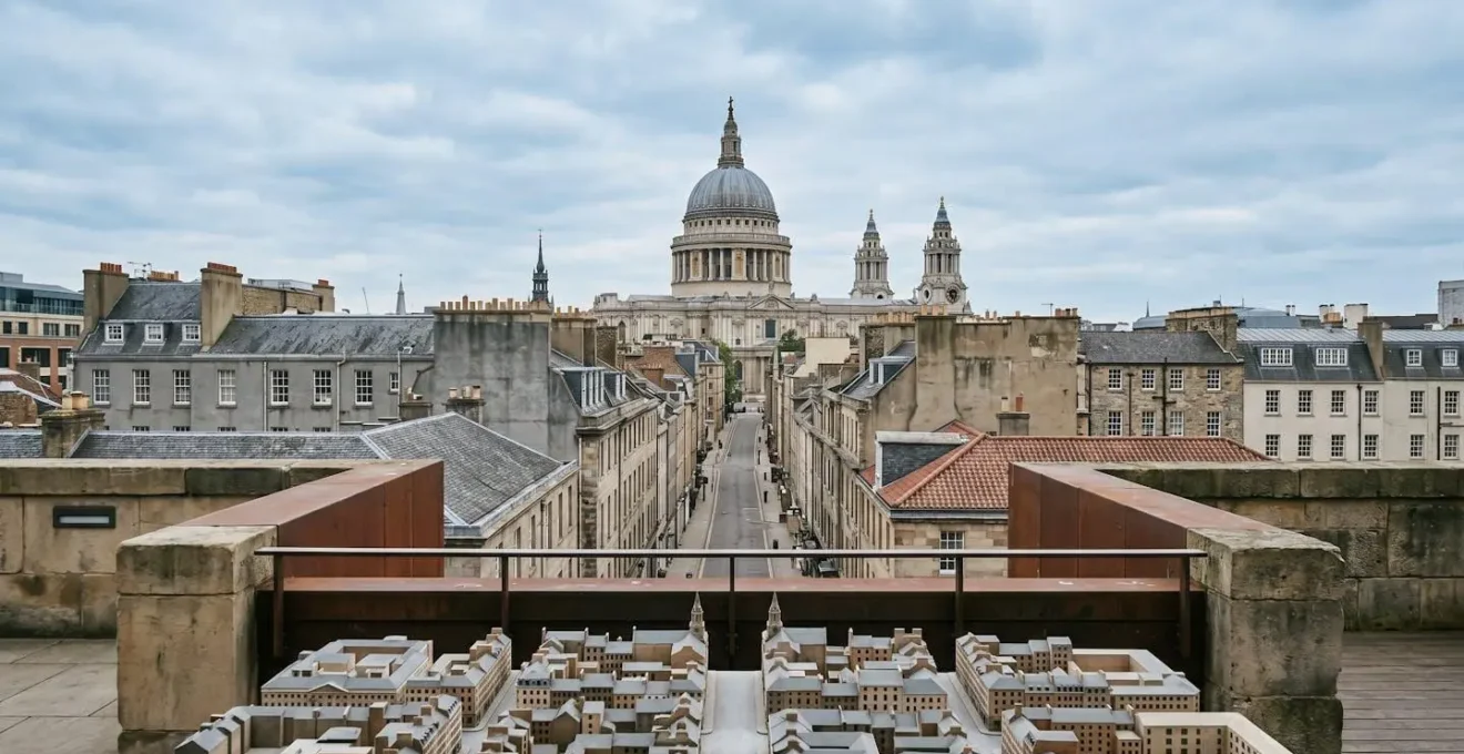
This visual illustrates the concept of a protected corridor, where the right to a view is codified into law, forcing development to conform to the public realm, not the other way around. The most famous example demonstrates the power of this approach.
Case Study: London’s Protected View of St. Paul’s Cathedral
Established in 1710, the view from King Henry VIII’s Mound in Richmond Park to St. Paul’s Cathedral, over 10 miles away, is legally protected. This historic sightline is preserved by a literal keyhole cut into a hedge and a cleared avenue through a wood. The protection is so stringent that it has directly limited the height and massing of modern skyscrapers in London’s financial district, which would otherwise form an unacceptable backdrop to the cathedral’s famous dome. This single protected view demonstrates a multi-century commitment to a public visual asset over private development potential.
This stands in stark contrast to New York, where views of landmarks like the Empire State Building or the Statue of Liberty have no such legal protection and are routinely obstructed. The comparison is clear: one city plans proactively to protect its shared identity, while the other reacts passively to the demands of the real estate market.
The 2050 Waterfront: Planning for Rising Sea Levels
The relentless focus on vertical expansion raises a critical question of priorities. As the city invests its spatial and political capital in facilitating supertalls for a global elite, it faces far more existential threats that demand a different kind of planning. The most pressing of these is climate change and the reality of sea-level rise along New York’s extensive waterfront.
True long-term urban planning would prioritize resilient infrastructure, green waterfront parks that act as storm surge barriers, and adaptive reuse of existing buildings. Instead, the current paradigm continues to incentivize the construction of new, energy-intensive luxury towers. This creates a bizarre paradox: the city’s planning apparatus is geared towards producing more private, high-emission real estate at the very moment it should be focused on public, climate-resilient infrastructure.
This disconnect is further highlighted by the state of the city’s existing commercial building stock. In the post-pandemic era, the demand for traditional office space has plummeted. A 2024 analysis found that over 18% of Manhattan offices are empty, a near-record high. Yet, rather than focusing policy on converting these vacant spaces into much-needed housing or other uses, the city’s development engine continues to churn out new super-luxury residential towers. This reveals a planning system driven by the logic of new, high-value construction, not by the actual needs of the city or the urgent realities of our changing environment. The focus remains on maximizing the vertical tax base, even if it means ignoring the horizontal vulnerabilities.
How Developers Buy « Air » from Neighbors to Build Higher Than Allowed
Perhaps the most abstract yet powerful tool in a developer’s arsenal is the ability to purchase « air. » Transferable Development Rights (TDRs), commonly known as air rights, are a prime example of zoning as a commodity. The city’s zoning code assigns a maximum Floor Area Ratio (FAR) to every property, dictating the total buildable square footage. If a building, often a historic landmark or a low-rise structure, does not use all of its allotted development rights, it can sell this « unused air » to an adjacent property.
The buyer can then add this square footage to their own project, allowing them to build a tower far taller and bulkier than their own lot’s zoning would normally permit. As explained by building industry experts, this is a core strategy for maximizing profit and exclusivity.
By buying the ‘air rights’ from adjacent properties, the developers of the supertalls ensure that the views of their units are never blocked, and they can go higher on their own property.
– Fred Mills, B1M
This creates a speculative market for empty space, where air itself is priced and traded. The potential for this is vast; comprehensive mapping by the Municipal Art Society reveals the enormous volume of available air rights across the city, representing a massive, invisible reservoir of future development potential. For the public, this process is opaque and its consequences—taller buildings, deeper shadows, and increased density—materialize with little to no public input, as these transfers often occur « as-of-right. » It is the ultimate expression of a system that allows private capital to rewrite the public skyline, lot by lot.
Selfie Bait vs. Public Art: What Makes a Structure Meaningful?
The final justification for these massive structures often comes wrapped in the language of iconic architecture and public art. Structures are presented as new landmarks that add to the city’s dynamism. However, a critical analysis reveals a different function. Many of these supertalls and their associated « public » features are not integrated parts of the urban fabric but are, in effect, financial instruments and marketing tools. They are designed for the global image of New York, not the daily life of New Yorkers.
This is reflected in their occupancy patterns. A significant real estate analysis shows a high percentage of units in these towers are not primary residences. They are traded as assets, parked capital in a stable market, or used as occasional pieds-à-terre. They are homes for wealth, not for people. This transforms them from residential buildings into a form of vertical bullion, contributing to the tax base but adding little to the city’s social vitality.
This reality is not lost on local officials who witness the hollowing-out effect on their communities. As former City Councilman Corey Johnson stated at a community meeting on the towers, the target audience is not New Yorkers:
Most of these apartments are being sold to foreign investors, who have tens, if not hundreds of millions of dollars, who are not making this their primary home.
– Corey Johnson, NPR
In this context, the architectural merit becomes secondary to its function as « selfie bait »—a spectacular backdrop for social media that signifies wealth and global status but lacks deep, meaningful connection to the public life at its base. It is a structure to be looked at from afar, not lived in or around. This separates it from true public art, which engages with and enriches the community, transforming a space rather than just occupying it for private branding.
Key Takeaways
- « As-of-Right » is a Super-Loophole: This single principle allows developers to bypass public review and environmental studies, rendering community opposition and shadow concerns largely irrelevant if basic zoning is met.
- Public Space is a Bargaining Chip: Programs like POPS have created a system where developers receive massive, permanent zoning bonuses in exchange for what are often minimal, low-quality, or unwelcoming « public » amenities.
- Air Rights Privatize the Skyline: The ability to buy and sell unused development rights (air rights) creates a speculative market that allows buildings to grow far beyond their intended scale, all without public oversight.
Why New York’s Super-Tall Skyscrapers Are Casting Longer Shadows on Central Park?
The long shadows creeping across Central Park’s Sheep Meadow and playgrounds are not an unforeseen consequence of development; they are the final, visible symptom of all the systemic issues discussed. The shadow itself is the physical manifestation of a planning framework that has been systematically engineered to prioritize the private vertical realm over the shared horizontal one. When a developer can build « as-of-right, » purchase air from neighbors to gain height, and satisfy « public space » requirements with a sterile corporate lobby, the shadow is the inevitable result.
The scale of this impact is no longer theoretical. Advocacy campaigns have documented how these new towers cast shadows that, according to the Stand Against the Shadows campaign, stretch up to three-quarters of a mile into the park, darkening everything from carousels to ballfields. This loss of sunlight is a direct expropriation of a public good, traded for the private benefit of a few dozen penthouse views.
The core of the problem, as articulated by groups like Landmark West!, is that the city’s zoning code has not kept pace with architectural and financial innovation. « Supertall developments are simply not part of the plan that City Planning envisioned, and the Zoning Resolution needs to be amended to reflect their reality. » Without such an amendment, residents are left with few options, often forced to use personal funds to hire consultants and file legal challenges against projects that are, by the letter of the outdated law, perfectly legal. The shadow on the park is, therefore, a shadow of a flawed democracy, where the legal tools available to the public are no match for the capital and legal machinery of modern real estate development.
Ultimately, challenging this trajectory requires more than just opposing individual projects. It demands a fundamental re-evaluation of the city’s planning priorities, moving away from a system of loopholes and trade-offs and toward a clear, legally-enforced vision of the public good. To reclaim the city’s shared spaces, residents must first understand and then challenge the invisible architecture that is giving them away.